Best time to travel to Oregon

Ramona Falls in Oregon

A beautiful waterfall on the west side of Mount Hood

Best time: May–October

Ramona Falls
Ramona Falls

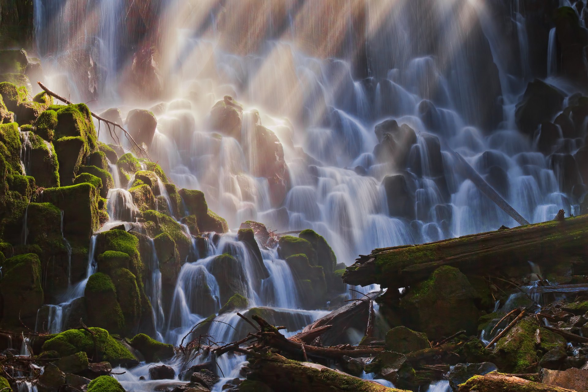
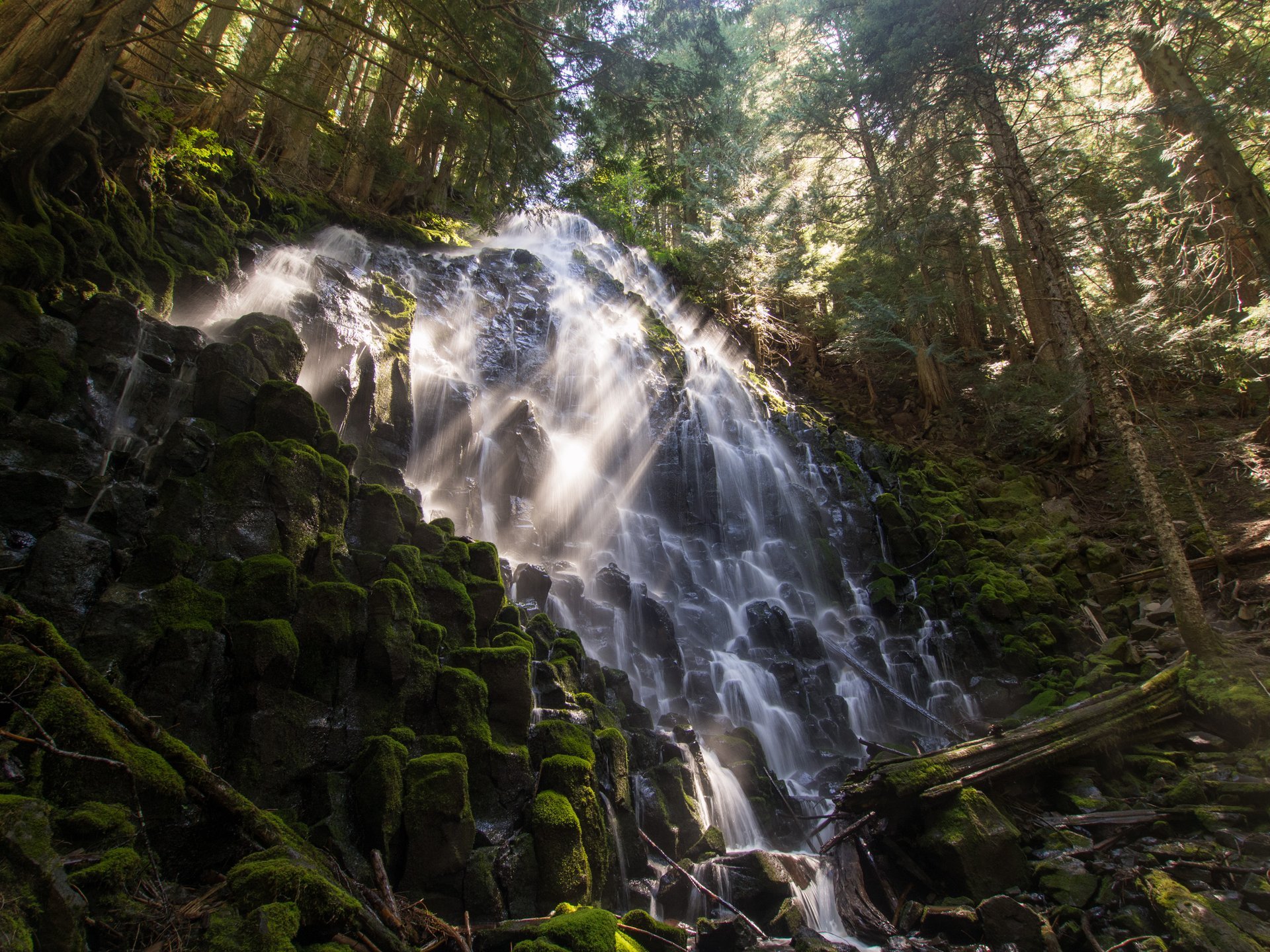
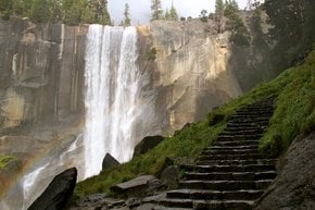
Ramona Falls is a popular waterfall on the upper Sandy River, located in the Mount Hood Wilderness, Oregon. Glacier-fed Sandy River produces the 120-ft (37-m) cascades that draw a lot of visitors to the western side of Mount Hood. The Ramona Falls Hike located at an elevation of 3,560 ft (1,085 m) along the Pacific Crest Trail is an easy one-day family hike not far from to Portland.

The Ramona Falls Trail is a 7-mi (11-km) roundtrip hike that goes through beautiful forested wilderness rich with Douglas-firs and lodgepole pines and along sandy banks. The trailhead is located near Zig Zag Ranger Station on Lolo Pass Road. The trail starts on the sandy river bed. In about 3.5 mi (5.6 km) hikers reach the beautiful waterfall plunging down on mossy rocks. Some of the trails in Mount Hood area are closed from December 1st to April 1st. The best time to visit the falls is from May through October since the trail features Sandy River Crossing that is easier during that time. Note, that between May 15th and October 1st, you'll be required a valid Recreation Pass at Ramona Falls trailhead.

From Ramona Falls the trail continues to Bald Mountain and McNeil Point, the beautiful Yocum Ridge, and wildflower meadows of Paradise Park.

Practical info

When is the best time to go to Ramona Falls in Oregon?

Ramona Falls is best visited from May through October as the Sandy River Crossing can be managed easily by hikers. It is worth noting that visitors need valid Recreation Passes at Ramona Falls trailhead between May 15th and October 1st. From December 1st to April 1st, the trail may be closed, making spring and summer the most appropriate months to visit. Show more

Where is Ramona Falls located?

Ramona Falls is situated on the eastern side of Mount Hood in the Mount Hood Wilderness region. Visitors can easily access the waterfall by hiking along the Pacific Crest Trail, on a family-friendly trail about 7 miles (11 kilometers) long. Zig Zag Ranger Station is the nearest ranger station for hikers, and the trailhead on Lolo Pass Road is about one hour's drive from Portland. Show more

How long is the Ramona Falls Trail?

Measuring about 7 miles (11 kilometers) roundtrip, the Ramona Falls Trail is a family-friendly hike that passes through a forested wilderness. During the hike, visitors can enjoy breathtaking scenery along sandy banks and see a variety of trees including Douglas-firs and lodgepole pines. The hike typically lasts 3-4 hours depending on one's pace or breaks taken. Show more

What type of trees are found along the Ramona Falls Trail?

The Ramona Falls Trail boasts a variety of trees aside from others and one can easily spot Douglas-firs and lodgepole pines as they hike. These trees are often found up in the mountains and are sequestered by the stunning Pacific Crest Trail scenery. Their presence provides shade cover, scenic beauty, and an awe-inspiring landscape for trail takers. They are essential to the local ecosystem. Show more

Are there other attractions or activities near Ramona Falls besides the waterfall?

Ramona Falls visitors can also enjoy McNeil Point which offers a panoramic view of the rural, densely forested surroundings. Travellers can explore Paradise Park and appreciate the view of wildflower meadows which is another attraction near the area. Hikers interested in multi-day hiking experiences can explore the Pacific Crest Trail, making the Ramona Falls trail a great starting point for such adventures and other destinations awaited along the way. Show more

Ask a question

Find hotels and airbnbs near Ramona Falls (Map)

Last updated: