Hiking Mount Roraima in Venezuela 2025-2026
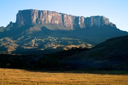
The tripoint of Venezuela, Guyana and Brazil, this mountain is often called a floating island due to its shape
Best time: December–April
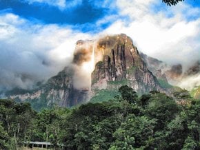
A true natural wonder, Mount Roraima plateau may appear to be floating on a cloudy day. It sits 2,338 m (7,671) feet above the forest floor. In South America, this one is the highest in the Pakaraima chain of tepui plateaus, its huge summit area covers 31 sq. km (12 sq. mi). Mount Roraima belongs to some of the oldest geological formations on the planet, dating back two billion years ago. The unique ecosystem of a mountain range features many endemic plant and animal species. There are also a few beautiful waterfalls, some of the highest in the world.
Located on the Guiana Shield in the southeastern corner of Venezuela's Canaima National Park, Mount Roraima is the highest point of Guyana and the Brazilian state of Roraima. The border line between the countries intersects on the mountain's massive shelf. The only way to climb to the top of this Tepui is from the Gran Sabana side in Venezuela.
A Mount Roraima trekking trip usually takes around a week. Up to two days are needed to reach the base of the peak, whereas the hike to the top and back takes about four days. Besides, you may want to spend a day on top.
The best time for a hike is in the dry season from December to April. Rainy season is less safe, yet stunning with waterfalls. Also, bear in mind in the dry season it still rains almost every day at the summit. It can get quite chilly too, so don't forget warm clothes.
Roraima Tepui name is derived from 'Roroi-ma,' that in Pemon language means 'big blue-green.' Tepui or tepuy stands for table mountain in Spanish. The mountain plays a significant role in the folklore of the local tribes. It also inspired Arthur Conan Doyle’s novel The Lost World.

